
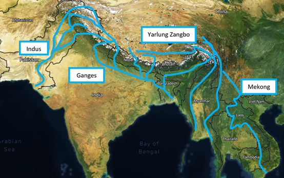
Water resources are becoming critical to growing populations across the planet and the Asia-Pacific region looks like it will be one of the most critical regions for water consumption in the future. China controls rivers that are critical to 2.1 billion people across Asia through its invasion of Tibet and Xinjiang in the middle of the 20th century. The Indus, Ganges, and Mekong rivers are just a few well-known rivers that start in China. These rivers have headwaters that start on the Tibetan Plateau and flow into Pakistan, India, Myanmar, and the rest of Southeast Asia. Currently, China is building mega-dams along each of these rivers that can choke back the flow of water or divert the water entirely to suit the needs of China. If Beijing decided to restrict water that flowed from Tibet during a border dispute or a war, it would easily devastate countries across the region.
These dams can yield massive amounts of electrical energy but only for a fraction of China’s population located in the western part of the country. Beijing can use ultra-high voltage direct current (ultra-HVDC) to transport the energy to cities like Chongqing or Chengdu with little loss in energy. This will require massive infrastructure investment across the country and the electricity is unlikely to be used for China’s eastern mega-cities. But even if these dams are completed and the infrastructure is in place, they will not be a run of the river hydropower project. These dams will be the largest dams in the world and could divert critical water supplies from regions with some of the highest population densities on the planet.
Directing these rivers to the northeast of the country along the Yellow River where Beijing desperately needs water will be a great coup for China. This will allow them to provide the country with soft power when dealing with the 18 countries that have border disputes with them, allow China to leverage resources on ASEAN, enforce China’s 9-dash line claim in the South China Sea, reinforce their impending invasion of Taiwan, allow China’s civilian fishing fleets to invade territorial waters or just allow Beijing’s access to international markets.
Pakistan
Pakistan has been deepening its military and economic ties with China and is one of the few countries in Asia that does not have a border dispute with Beijing. China has been developing the Karakoram Highway that leads from Xinjiang to Karachi, building a port on the Iranian/Pakistani border in Pakistan controlled Baluchistan, mining rare earth minerals in Pakistan controlled Baluchistan, and has been building dams for Pakistan in the disputed region of Kashmir. The Indus River cuts straight through the middle of Pakistan and continues down to Karachi which is a city of 16 million people.
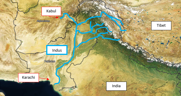
This river serves as the lifeblood of the Indus Valley where civilization first began. The headwaters of the Indus River flow from the Tibetan Plateau through Kashmir and down to the Arabian Sea near Karachi. The Indus River’s watershed is fed from rivers that begin in Tibet and is fed by rivers that cut through Northwest India. India has threatened to suspend the Indus Water Treaty that allows water to flow into Pakistan several times after cross-border skirmishes and recently review the treaty in 2016 saying that water and blood should not flow together after cross-border attacks. The Indus Water Treaty allows India to build run of the river dams along the lower 3 rivers that cut through Indian-controlled Kashmir. This treaty also allows Pakistan control of the upper rivers that feed into the Indus River through Kashmir. China could easily suspend any treaty that allows Tibetan water to flow into Pakistan if there was any criticism against Beijing’s policies towards its Muslim population and starve Pakistan of much-needed water in a desperately dry region.
Nepal
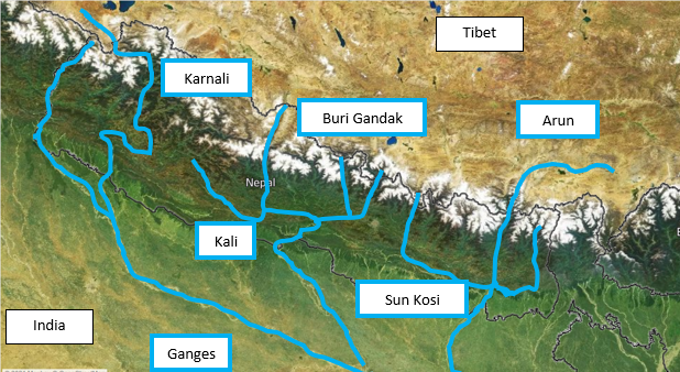
Nepal is heavily dependent on water that comes from the border region with China. The Arun River (Sun Kosi) has headwaters that start on the northern slopes of Mount Everest and join the Sun Koshi (Bhote Kosi) before feeding into the Ganges in India. The Karnali River is another tributary of the Ganges that has headwaters on the Tibetan Plateau and flows through Nepal. The Trishuli River has the interesting distinction of housing the Resuo bridge, which is the main international crossing between Beijing and Nepal. This bridge is critical because India could have trouble getting supplies into Nepal during the winter months.
India
India has had a tense relationship with China with their rivalry leading to border skirmishes and China funding India’s adversary, Pakistan. India and Beijing have a border dispute that recently led to a high-altitude skirmish and the two countries are developing forward operating bases on the Tibetan Plateau. The Ganges, which was named after the Hindu god of Ganga, is a river that has significant economic and spiritual value for the people of India and the river has headwaters that begin on the Tibetan Plateau. This river is an important place of pilgrimage where ashes of the cremated are spread across the river. Some of the headwaters that begin in Tibet and cut through Nepal and China could easily squeeze India by lowering the level of the Ganges by diverting feeder rivers that cut through Nepal to eastern China.

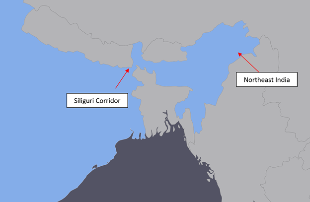
China is also building large dams along the Bhutan border that has been described as a “bomb” that could be used to flood Northeast India in a time of crisis and allow China to take the Siliguri corridor (the “chicken’s neck”). This would allow China to take Northeast India without a fight. China has a “historic” claim to parts of Northeast India and could use a wall of water to flood the region before a war. It’s important to note that both China and India have been trying to tame this river that leads to uncontrollable flooding in the area and that the dams just represent this passion to control these rivers and nothing else.
China’s diversion of these rivers could hurt India and Nepal by diverting the Ganges critical water supplies, but if China’s mega-dam on the Great Bend diverts this river, it could also inversely impact Bangladesh as well. The Ganges flows from India into Bangladesh where it feeds 164 million people. India built the Farraka Barrage in 1975 along the Ganges without the approval of Bangladesh that led to severe water shortages in 1976 before the two countries signed a 30-year treaty in 1996. China could easily do this to put pressure on India to give up territory in Kashmir or to force India to support a war against Taiwan.
Bangladesh
The Ganges is not the only river that India and Bangladesh depend on China for their water resources. The Yarlung Zangbo (Brahmaputra in India) is a river that cuts through Tibet and flows East before an abrupt turn through Northeast India and then flows into Bangladesh.

Several dams have been proposed by both China and India but the timing of the recent announcement that Beijing plans to build yet another dam on the Brahmaputra after the high-altitude skirmish in Ladakh is a telling sign for India. This coupled with China’s claims on India’s territory and the fact that they are building the world’s largest hydropower project could mean that China could potentially turn the Yarlung Zangbo river before it turns into India and Bangladesh. This diversion of the water for their own use would be used as a weapon if war were ever to break out between these two countries. China’s mega-dams could spell disaster for Bangladesh that relies on both China and India for a substantial portion of its freshwater.
Myanmar
Myanmar is the next country that is dependent on China for its water. The Gyalmo Ngulchu (known as Salween in China) flows from the Tibetan Plateau into Myanmar along the border of Thailand and is the last major free-flowing river in Asia. Irrawaddy is the largest river in Myanmar and its headwaters come from the border with China. Its main feeder is the Dulong Jiang that originates on the Tibetan Plateau and runs through Yunnan in China before feeding into Myanmar.
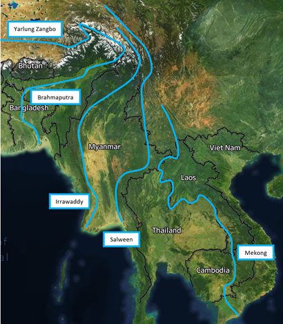
Mekong
But the largest and most controversial dam projects are occurring along the Mekong Delta. China has built a series of dams that resulted in the destruction of the river and water levels have been reaching record lows. Southeast Asian countries have responded by building their own dams along the river, but China ultimately controls the water level.
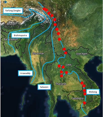
The Mekong River is a lifeline for farmers of rice, fisherman, and transporters of goods. In 2019, the river dropped to lows not seen for more than a century due to droughts in the area but many countries attributed the drop to the development along the river. China has built 11 mega-dams and has even chocked backwater to test a dam’s integrity. A week later, China only made the announcement after a Washington-based organization reported that the Mekong dropped approximately 3 feet. Run the river dams allow water to pass through the dam but countries are developing reservoirs to temporarily hold critical water needed for countries downriver.
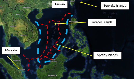
South China Sea
While freshwater is critical for countries in Asia, nautical boundaries are just as important because they contain important fishing stocks that Asian countries rely upon. Some ASEAN members (Southeast Asia’s response to the EU) have been a thorn in Beijing’s side contesting China’s 9 dash line claim to the entire South China Sea. Below is a map of China’s claim to the South China Sea in blue and the other countries’ territorial waters in red.
Countries’ levels of protests range from protesting to the US or the UN to developing Russian military bases, to trying to appease Beijing in hopes that China will see them as an ally. China’s control of the Spratlys would allow Beijing to create forward operating bases within eyesight of the Philippines and Vietnam shore. Having these forward operating bases would allow China to enforce enormous power over these countries. China could also use these countries’ territorial integrity to gain complete control over rare earth deposits in the South Chinese Sea or billions of dollars of trade that flows through the strait of Maccala. China is also desperately in need of fish stocks and its civilian fishing fleets have been spotted all over Africa, South America, and Central America dragging the seas dry.
China
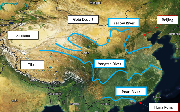
China could even follow through with Guo Kai’s Grand Western Water Diversion Plan (GWWD) to divert water from the Tibetan Plateau to Northern China. The GWWD could force Tibetan water to follow the Yellow River where Beijing could carve out a new path that will allow water to flow through the Gobi Desert supplying much-needed water to Northern China. Beijing could also force water to the Yangtze River feeding millions of people in the inner regions of the county and Shanghai or diverting water to the Pearl River for people living in Hong Kong and Macau. This would benefit Beijing but could deprive 2.1 billion people of critical water supplies causing widespread famine and mass movement of population.
Another likely scenario is that China uses water resources to pressure any number of the 18 countries it has border disputes with (not counting China’s claim to parts of the North Pole). These countries would have to capitulate to Beijing’s demands on any number of issues ranging from Taiwan to the South China Sea to even war with an unspecified aggressor.
This should be a concern for every politician in the United States because China could use these water rights and border disputes to enforce its own hegemony over the planet.